| |
Oil
Exploration
Oil is a fossil fuel that can be found in many
countries around the world. In this section, we will
discuss how oil is formed and how geologists find it.
Forming
Oil
Oil is formed from the remains of tiny plants and animals
(plankton) that died in ancient seas between 10
million and 600 million years ago. After the organisms
died, they sank into the sand and mud at the bottom of
the sea.
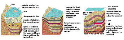
Photo courtesy Institute
of Petroleum
Oil forms from dead organisms in
ancient seas.
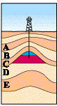
Over the years, the organisms
decayed in the sedimentary layers. In these
layers, there was little or no oxygen present. So
microorganisms broke the remains into carbon-rich
compounds that formed organic layers. The organic
material mixed with the sediments, forming fine-grained
shale, or source rock. As new sedimentary
layers were deposited, they exerted intense
pressure and heat on the source rock. The heat
and pressure distilled the organic material into
crude oil and natural gas. The oil flowed from
the source rock and accumulated in thicker, more
porous limestone or sandstone, called reservoir
rock. Movements in the Earth trapped the oil
and natural gas in the reservoir rocks between
layers of impermeable rock, or cap rock,
such as granite or marble.
|

Photo courtesy
Institute of Petroleum
Close-up of reservoir rock
(oil is in black)
|
Photo
courtesy Institute of Petroleum
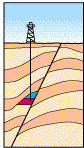
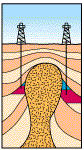
Oil reservoir rocks (red) and
natural gas (blue) can be trapped by folding (left),
faulting (middle) or pinching out (right).
|
These movements of the Earth include:
- Folding - Horizontal movements press
inward and move the rock layers upward into a fold
or anticline.
- Faulting - The layers of rock
crack, and one side shifts upward or downward.
- Pinching out - A layer of impermeable rock
is squeezed upward into the reservoir rock.
Finding Oil
The task of finding oil is assigned to geologists,
whether employed directly by an oil company or under
contract from a private firm. Their task is to find the
right conditions for an oil trap -- the right source
rock, reservoir rock and entrapment. Many years ago,
geologists interpreted surface features, surface rock and
soil types, and perhaps some small core samples obtained
by shallow drilling. Modern oil geologists also examine
surface rocks and terrain, with the additional help of
satellite images. However, they also use a variety of
other methods to find oil. They can use sensitive gravity
meters to measure tiny changes in the Earth's
gravitational field that could indicate flowing oil, as
well as sensitive magnetometers to measure tiny
changes in the Earth's magnetic field caused by flowing
oil. They can detect the smell of hydrocarbons using
sensitive electronic noses called sniffers.
Finally, and most commonly, they use seismology,
creating shock waves that pass through hidden rock layers
and interpreting the waves that are reflected back to the
surface.
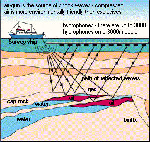
Photo
courtesy Institute of Petroleum
Searching for oil over water
using seismology
|
In seismic surveys, a shock wave is
created by the following:
- Compressed-air gun - shoots pulses of air
into the water (for exploration over water)
- Thumper truck - slams heavy plates into
the ground (for exploration over land)
- Explosives - drilled into the ground (for
exploration over land) or thrown overboard (for
exploration over water), and detonated
The shock waves travel beneath the surface of the
Earth and are reflected back by the various rock layers.
The reflections travel at different speeds depending upon
the type or density of rock layers through
which they must pass. The reflections of the shock waves
are detected by sensitive microphones or vibration
detectors -- hydrophones over water, seismometers
over land. The readings are interpreted by seismologists
for signs of oil and gas traps.
Although modern oil-exploration methods are better
than previous ones, they still may have only a 10-percent
success rate for finding new oil fields. Once a
prospective oil strike is found, the location is marked
by GPS coordinates on land or by marker buoys on water.
back
|
|